We are currently at 10° 20′ 2.39″ N 75° 50′ 4.84″ W, about 15 miles from Cartagena, Colombia. Part of the fun of being on a working container ship is that you really have no guarantee regarding the port stops.
We knew we’d get to Cartagena this afternoon, we just didn’t know when we’d get to Cartagena. So far we’ve been drifting about 15 miles from Cartagena since about 2 in the afternoon. With the clouds and haze in the air, land is just far enough away to be invisible. At one point in the late afternoon it cleared enough to see some ivory-colored skyscrapers on the coastline through the binoculars.
There’s a lot of slack built into the ship’s schedule. I’m guessing the padding allows us to absorb any unexpected cargo or weather delays. It also means that every day from around 1 or 2 in the afternoon until about 8 or 9 at night, the boat’s engines are turned off and we just drift. Right now we are waiting for the pilot to take us into the port.
We were on the bridge after dinner when we learned that the pilot would boarding at 2230 (in about an hour). We probably won’t be docking until midnight. Apparently cargo operations generally take about 10 hours—but it all depends. We could be leaving Cartagena tomorrow at 10 in the morning, or noon (or later). We won’t really know until they get the cargo plan after we dock.
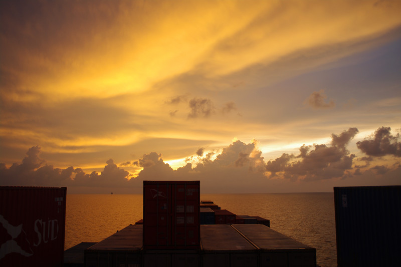
So, no stories of Colombian coffee, or photos of the old port yet. But Stephanie and I are planning on setting the alarm for 6 in morning to see if we can get out for a quick taxi ride around the city. Fingers crossed. For now, here’s a view of the sunset tonight out our cabin window.
We are currently at 15° 14′ 54.77″ N 75° 15′ 12.63″ W, somewhere between Jamaica and Colombia, en route to Cartagena, Colombia. We should be arriving there tomorrow afternoon. I am posting this (and anything else that begins with GPS coordinates) using a Wideye Sabre 1 BGAN Terminal (or in layman’s terms: a satellite modem).
When we started planning this trip, I had resigned myself to a month without access to the internet. It sounded like a badge of courage when people asked me, “So, does the container ship have wireless?” and I answered: “Nope.” The last time I didn’t have access to the internet for 28 days straight was probably before I had access to the internet at all.
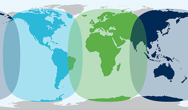
I’ll admit, I am weak. I did some cursory looking into satellite phones, Iridium and such. But they were just blindingly expensive. And I didn’t want to make calls, I just wanted an IP address! Eventually I stumbled upon Inmarsat’s BGAN, which stands for Broadband Global Area Network. Unlike the various satellite phone options, many of which only guaranteed coverage on land, BGAN covers the whole planet, continents and oceans, with the exception of the poles. It was almost too good to be true.
We are currently at 19° 7′ 9.87″ N 74° 25′ 2.45″ W somewhere west of Haiti, en route to Cartagena, Colombia. We passed within 6 miles of the eastern tip of Cuba this morning (20° 3.020′ N 74° 1.863′ W at 10am), close enough to see it looming off the starboard side of the ship.
The eastern tip of Cuba
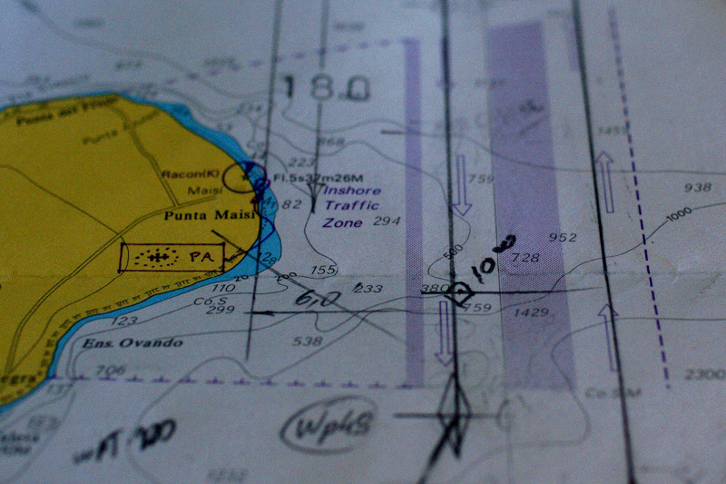
Apparently sea traffic is so busy around this point that there are designated “lanes” for northbound and southbound vessels. Neat!
Nautical chart showing the traffic lanes east of Punta Maisi, Cuba
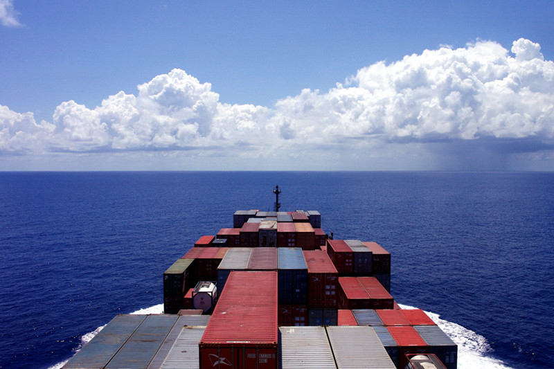
After breakfast in the mornings (it’s from 7:30-8:30, though we don’t usually get to the officer’s mess until about 8:20) we’ve gotten in the habit of going up to the bridge to chat with Jeoffrey, the third mate, who’s on duty until noon. We have tea, lounge in the captain’s chairs, and listen to stories about the seafaring life or his friends and family in the Philippines. He’s also been teaching us how to control the ship. As we came around Cuba, Stephanie changed the ship’s heading from south to southwest (at the point marked by the diamond above), in the direction of Cartagena. Here’s a great view looking forward from the bridge.
We are currently at 23° 18′ 3.45″ N 74° 36′ 56.55″ W, somewhere east of the Bahamas, en route to Cartagena, Colombia. We gained an hour tonight.
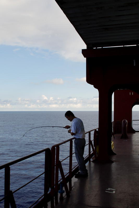
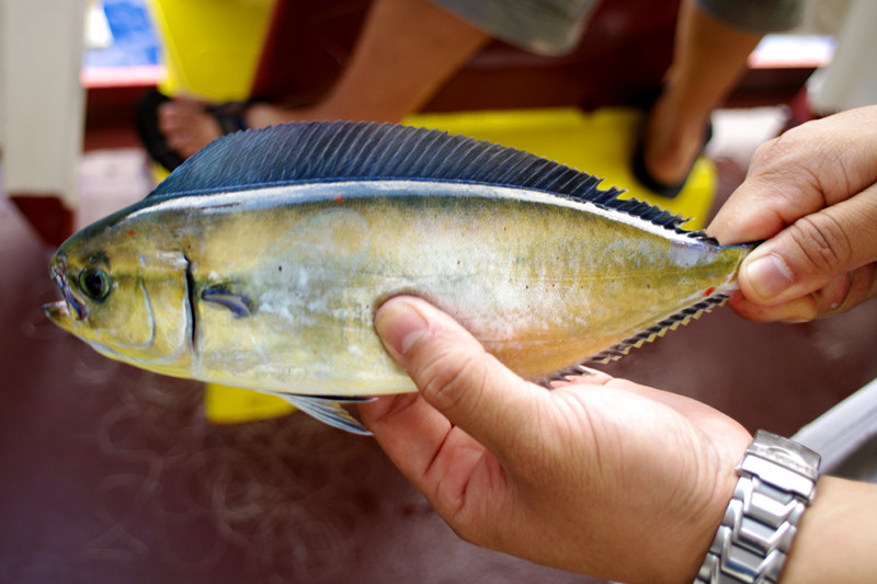
Something to add to Stephanie’s container ship FAQ: Can you fish off a container ship? My immediate response was: no way. A container ship just seems too big and too industrial—and how could anyone fish while the ship was moving?
Well for one, the ship is not always moving. Sometimes when we’re ahead of schedule they just let it “drift” for a few hours. And it turns out that it doesn’t matter how big your boat is, if you’ve got a long enough fishing line, you can fish off of anything.
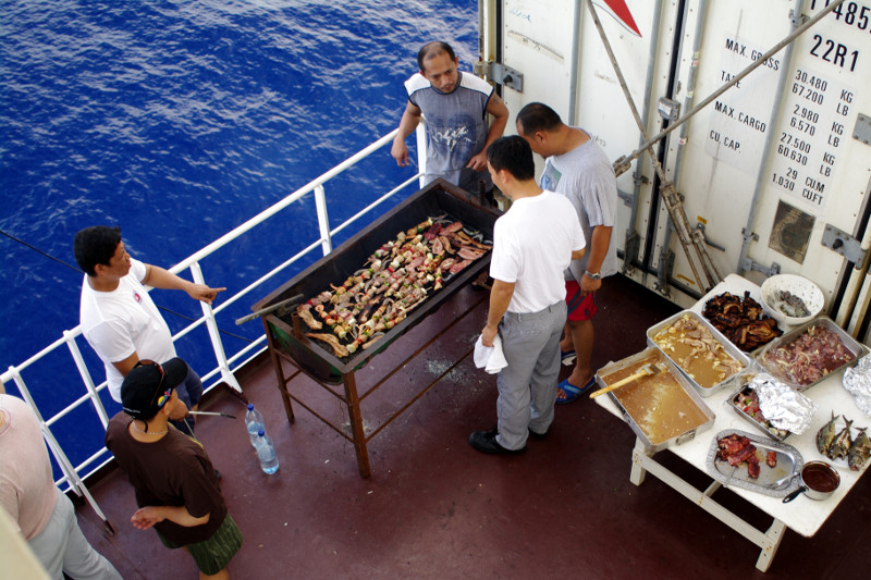
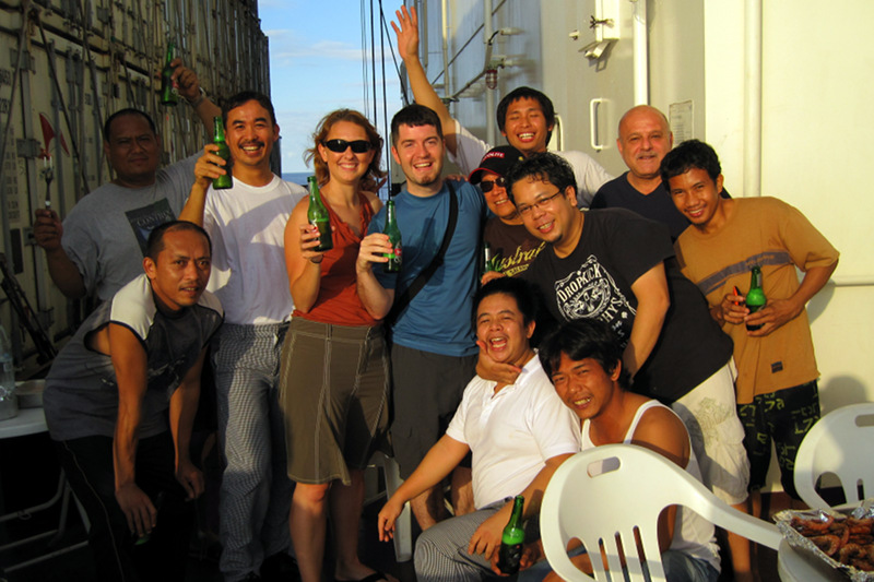
The captain declared that tonight there’d be a barbecue party (they usually have them once a voyage) and the whole crew came together on the main deck, grilling shrimp, squid, pork bellies, kabobs, chicken, hot dogs, as well as three fish they caught right off the side of the ship. Of course there was drinking, music, dancing, drinking, dancing…
Chief Cook Danilo fishing off the side of the shipFreshly caught fishContainer ship barbecueGroup shot (pre-debauchery)
We are currently at 28° 57′ 2.16″ N 78° 1′ 6.09″ W, somewhere off the coast of Florida, en route to Cartagena, Colombia. We’ve been on the ship for five days already, so I’ve got a little catching up to do.
On Tuesday we boarded the Cap Cleveland midday, and pretty much hung out in our room, transfixed by the scene outside our window: giant cranes lifting heavy containers into place with incredible precision. Dinner is from 5:30-6:30 in the officer’s mess, so we showed up promptly at 5:30 and met the only other passenger: Noah, a composer from NYC. He’ll be on the ship for the entire 70 day round trip! Dinner was a pork chop with gravy and a Greek salad. It was surprisingly savory, tasty, and fresh. We ate alongside some of the engineers, but they didn’t say much. Later that night we felt the ship start to pull away from the port, so we went up to the bridge, and stood in the dark as the river pilot navigated the ship out to the open ocean (a six hour process—we stuck around for about an hour before heading to bed).
We were both groggy on Wednesday. No seasickness, but the gentle rocking of the ship and vibration of the engine made it hard to stay awake during the day. We also discovered that the air conditioning was broken, and had been since the ship last came through the Panama Canal. They ordered a replacement part in Philadelphia, but got the wrong one. So I think the heat was also wearing us out. They brought out some padded deck chairs for us, and we spent a lot of time sitting outside to cool off. We were at sea all day, with no sight of land.
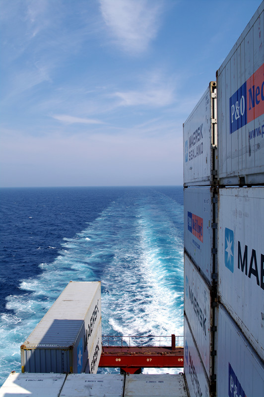
Looking back at our wake
The heat was really getting to us on Thursday. It had been very hard to sleep the night before, and to make matters worse, I woke up with a painful pulled muscle in my neck. We heard whisperings that they’d try to fix the AC in Savannah on Friday, but I also sensed an undercurrent of skepticism. So we tried not to get our hopes up. Once again it was pretty miserable getting to bed that night. By the time I finally resorted to sleeping pills, I noticed we’d pulled into Savannah (a little after 1am) and were beginning to dock.
We woke up on Friday with a mission. Troubleshoot my non-working satellite modem and buy a fan in Savannah! A taxi with access to the port picked us up at the ship around 9:30 and dropped us off at Starbucks in historic downtown Savannah. There we basked in the air conditioning, took advantage of the free wireless internet, and sipped on iced teas. First we updated our blogs and checked our email (like the internet addicts we are), then I proceeded to the more important matter at hand: figuring out how to use the BGAN satellite modem. Stephanie, love of my life, looked for lunch options, and with no prodding on my part, picked a highly reviewed barbecue joint within walking distance (Angel’s BBQ). We picked up a few things at CVS, including a fan, walked down to the historic River Street, and then spent our last hour or two of “shore leave” back at the Starbucks. We returned to the ship by 5:30, and what was that we felt? AC! They had fixed the air conditioning. We weren’t going to roast after all. Oh happy day.
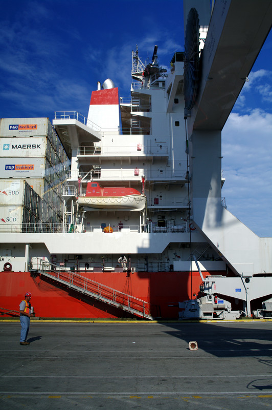
Superstructure of the Cap Cleveland
Saturday (today) was pretty chill (literally). It’s the weekend after all! Stephanie slept in, but I got up just in time for breakfast: raisin pancakes and sausage. I spent a few hours on the bridge chatting with Jeoffrey, the third mate, and learning how to read the ship’s navigation screens. Later Stephanie came up and joined us. We left Savannah sometime after 10pm the night before, thus it was the first of several days we’ll spend at sea. I believe we’ll be getting to Cartagena on the 15th, via a course east of the Bahamas and Cuba.