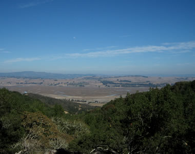
The park overlooks the Petaluma River and San Pablo Bay from the east-facing slopes of 1,558 foot Mount Burdell.
The name “olompali” comes from the Miwok language and may be translated as “southern village” or “southern people.” The Coast Miwok inhabited at least one site within the area of the present-day park continuously from as early as 6,000 BC, until the early 1850s.
I heard there was a good hike, and I wasn’t disappointed. There was a 2.5 mile loop off of which was a 3.3 mile trail up to the top of Mount Burdell. I packed a sandwich in my Camelbak which I’m loving (I got a black Lobo by the way) and started hiking up. The day was pretty clear, with a little haze in the distance, but lots of great views of the Petaluma River and surrounding floodplain.
I made it to the top around 3pm, 5 miles and 1200 foot change in elevation in about 2.5 hours. And then I had to go all the way back down again, 4 miles this time and I ran most of it (in some pain from being all sweaty) in an hour and a half.
Took my camera hiking through Annadel yesterday afternoon and decided to snap a few shots of the manzanita trees. I’d never seen a manzanita before moving to California.
They have a rather striking red bark that looks like the trees have been painted with an orange-maroon acrylic paint. I decided to play a little with Flickr, so I put a few of the best shots up in a manzanita set.Update: I decided to take the photos off of Flickr and add them to my blog below. Enjoy.
Christy and Marcus, whom I previously hiked with down in San Mateo County, were up in Cloverdale for the weekend and were interested in hiking Mt. St. Helena, the highest point in Sonoma County. It’s been on my list of hikes to do, but the 5 mile trek up (and 5 back) meant that I pretty much needed a whole day to undertake it. Update: Here’s a picture I took of Mt. St. Helena from Sebastopol.
It starts out with a number of switchbacks in a heavily wooded area. We pass a memorial to Robert Louis Stevenson who lived on the mountain (apparently inspiring some of the scenes in Treasure Island). Then there’s a pretty steep section that lets out onto a fire road with 4 miles to go. The nice thing about the fire road is that it makes for a pretty easy hike. The not so nice thing is that it provides no cover from the sun, which was a constant presence. That said, it was a beautiful day.
Along the fire road, there were some expansive views of Napa Valley below and the Sonoma Mountains in the distance.
We stopped in a shady area for lunch. I had tamari roasted almonds and cashews, sesame sticks, raisins, and a tomato and avocado courtesy of Christy and Marcus. I ran out of water and made yet another mental note to get a Camelbak. We got to the top of the south peak, a little over a mile before the higher north peak and decided we were satisfied (read: sufficiently tired) and could head back.
Here’s a topographic map of the south peak (courtesy of Topozone), which is about 300 feet below the north peak. I’ve highlighted the trail we took in blue. The Gmaps Pedometer said it was about 3.5 miles, one way.
On the way down, I finally remembered to have someone snap our picture.
As you can see, I’m wearing my hiking shirt. We got down to the bottom after 3pm, took a quick tour of Calistoga, including the nearby petrified forest, and headed back to Santa Rosa for some Nepalese cuisine at Annapurna, a few blocks from my apartment.
Last week I signed up for a Sea Kayaking Basics course at Blue Waters Kayaking so I could rent a closed deck kayak in the future. I was up at 7:30, the class started at 8:45.
I got my bathing suit and nylon shirt on, still unwashed from the previous weekend. Pulled together some fruit and a Clif Bar, and got going. As the crow files, Tomales Bay is only 20 miles from Santa Rosa, but the roads between here and there are not your average roads. These roads wind. The trip takes about an hour, especially if you get completely turned around and start inadvertently heading back the way you came!
Luckily I got myself reoriented and made my way to Marshall, on the mainland side of Tomales bay. The class had two other members, a man probably in his late 30s and his mother. They already own two kayaks, but were looking to improve their skills. We got into wetsuits (I don’t think my body is shaped appropriately for a wetsuit), packed our watertight bags, and put on skirts and floatation vests.
Our instructor, John, talked a little bit about the history and the shape of the boats. We’d be paddling in 15 foot long sea kayaks, learning a series of basic strokes and recovery techniques. The first rule of kayaking is: paddle with your torso and not your arms!
So we get in the boats, attach our skirts to the deck, and John pushes us off into the water. It’s kind of like being on ice skates for the first time (in a long time). Since I’m attached to the boat, small adjustments in my center of balance cause the boat to rotate dramatically to the left or the right. I don’t want to be the first to spill into the drink, but I worry it’ll be hard to know my limits until I do.
We practice a series of forward and reverse sweep strokes, intended to turn the boat without moving forward (much). Though the kayaks come with rudders, we won’t be using them, as they’d defeat the purpose of learning any proper strokes at all. After a good bit of practice, we learn the forward power stroke, and prepare to traverse the bay and lunch on the Point Reyes side.
According to the Gmaps Pedometer, a one way trip across the bay was about 0.82 miles. We stopped on a beach, and the sun conveniently broke through the fog long enough for me to wolf down a banana and a Clif bar. Now the real fun began.
John went over assisted and unassisted recovery techniques on the beach. The number of important steps to take so that one doesn’t fall back into the water while trying to get into their boat was alarming. Luckily I was nominated the first to capsize.
We paddled out, I gave a un-deux-trois, and rolled myself over. Cold. Water. Actually it wasn’t that bad, but it’s pretty shocking to be upside down and still attached to my boat. Thankfully I’ve been through this drill before—meanwhile the other guy’s mom was freaking out about having to do the same. I pull the skirt release tab and woo, I’m still alive.
This was going to be an assisted recovery, and John was going to be my assistant, so he walked me through the steps. I float towards the stern (the back), while he manuevers his kayak to the bow (the front) perpendicular to my upside down kayak. He grabs the bow (with two hands!) while I push down on the stern so he can yank my boat up onto his. He lifts it up so the water drains out while I bob in the bay. Then he turns it right side up and maneuvers it so our boats are parallel but facing in opposite directions. He takes my paddle, and holds onto the lip of my cockpit, creating a stable platform which I have to jump up on to (on my belly), then rotate around (still on my belly), push my feet down into the kayak (on my belly still), and then slowly rotate my body around and sit back up. Yey! A successful assisted recovery.
We then spend the next while practicing assisted and unassisted recoveries, the unassisted kind requiring a special paddle float that I assemble and inflate while my kayak patiently waits upside down. Once I get myself back in, having used the paddle+float as an outrigger, I get to bail the kayak out with a bilge pump. I admit this was all a lot of fun (maybe the most fun all day), and I managed to do about twice as many recoveries due to my lighting fast re-entry speed.
The wind and the waves started to pick up, so we began the journey back across the bay. The rougher conditions meant that I was mostly paddling on the left side just to keep the boat going straight, and even that wasn’t always enough. Eventually I made it back, practiced another unassisted recovery while the others came in, and that was pretty much it.
Except for food. Just down the way was The Marshall Shore, advertising the best barbecued oysters on the planet, and I hoped, a damn good chowder. It’s a really cute little place, right over the water, with a veritable ton of oyster shells lining the shore outside. Inside it’s set up like a general store, serve yourself, take your time, and pay before you go. I put my order of barbecued oysters in, helped myself to a cup of clam chowder, and cracked open a bottle of Boont Amber Ale.
For the uninitiated (of which I was recently one) a barbecued oyster is shucked, but left in the half shell. A little bit of butter and a ketchup based “barbecue” sauce is put on top of each and they’re cooked, shell-side down on the grill. I’m coming to realize it’s practically Northern California’s national dish. And I could have had a lot more than 6.
Out here in Sonoma County we get a fair amount of fog. In fact all week it was overcast and gray until the sun broke through for a few hours in the late afternoons. Of course Saturday was gorgeous, but I was more interested in working on my random image blog plugin than actually getting outdoors.
Thankfully Mark and Monica scooped me up that night and took me to a cookout with their friends and family in Graton (a town smaller than Sebastopol and a bit further north). I had the loveliest time out by their homemade (I should say home-welded) firepit, eating, talking, and watching the stars. It’s worth noting that my marshmallow roasting technique is unstoppable. Or so I was told.
So this morning I was eager to get out before sunset, given that I was treated again to sun and blue sky through my bedroom window. Santa Rosa is about 40 minutes from Bodega Bay (the closest ocean access) and an hour or so from Tomales Bay (between the mainland and Point Reyes). I decided it was time to take advantage.
So I called up a kayaking company and got the lowdown (they only rent open face kayaks until you’ve taken their class), signed up for the class next weekend, and got Marcia on board for a kayaking adventure on Tomales Bay this afternoon. We got there about noon, they supplied the kayak and wetsuits, a few pointers, and we were off.
Kayaking is always harder and less comfortable than I remember, probably because I’m not used to locomoting with my arms. I’m pretty sure the last time I was out in a kayak was the Outward Bound trip I took in Maine four years ago. But after a while I got into a groove, and it seemed like the most natural thing. We spent about two hours on the water, did a little exploring of a coastal cliff area, and ate the excellent sandwiches we’d picked up at Perry’s Deli in Inverness Park.
Not wanting to limit our adverture to upper body exertion only, we took the drive out to the Point Reyes Lighthouse with hopes that we might get a good view with the sun still out. The lighthouse is perched low on a cliff (to get below the fog) which requires a 300 step (or 30 story) descent in order to reach. Though no longer operational, it’s really quite something to see.
Of course what comes down must go back up. All 302 steps up.