Not only did we see a dance show and a movie last weekend, we also spent most of Sunday in Golden Gate park playing Pétanque on the 100th anniversary of the game.
Before I met Stephanie (well, Stephanie’s dad) I’d never heard of Pétanque. And before Sunday all I knew about it was a similarity to the Italian game of Bocce.
We got there a little after 11 and were immediately partitioned into different teams of three. Each player got two metal balls (boules) weighing about a pound and a half each. The hardest part from that point on was remembering whose boules were whose. Instead of each team using the same color, say, everyone had their own, differentiated only by the pattern of lines cut into the surface, and wear.
The game is played by members from each team tossing their boules down a semi-flat gravelly surface towards a small wooden ball (cochonnet) about 20 feet away. If your boule gets closest, then someone from the opposing team has to try to get closer or knock yours away.
This is of course where is gets tricky, because with 6 people playing, you’ve got 12 metal balls 20 feet away to keep straight. In the end, the team with the boule closest to the cochonnet can score up to 3 points, one for each boule that’s closest without an intervening boule from the opposing team. Of course half the time the boules seemed equidistant from the cochonnet, in which case, out came the rulers.
After my first game, we had some lunchy snacks, watched a demonstration, participated in a pointing and shooting competition, and then played some more games. I stuck with my original team. They weren’t a talkative pair, but they were good, and by late in the afternoon, we had cleaned up.
Oh Canada! So weird to be driving into a foreign country. Last Sunday (while in Buffalo, New York for my Grandfather’s 90th birthday) the whole family entered Canada via the Peace Bridge to visit Niagara Falls.
Canada sign on top of the customs plaza entering from the US
From there we drove up the Niagara Scenic Parkway, leisurely winding our way along the river to the Falls. Below is our first sight of the mist rising above Niagara Falls (and the plethora of hotels on the Canadian side).
Mist visible above Niagara Falls
We found parking and made our way down to a spot just across from the American Falls. The little chunk of falling water on the right is actually a separate waterfall, the Bridal Veil Falls.
The American and Bridal Veil Falls (as seen from Canada)
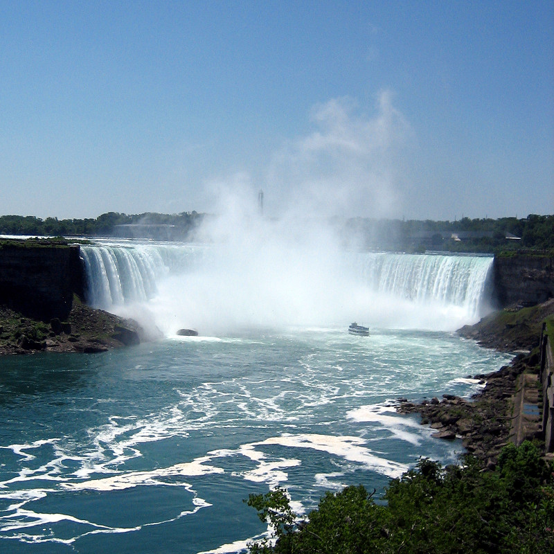
Then we walked over to view the Canadian side of the Falls, popularly known as “Horseshoe Falls” due to its iconic U-shape.
The world-famous Horseshoe Falls
Note: If you have any interest in buying a print of these photos, please don’t hesitate to send me an email.
I had no clue the Maid of the Mist basically “drove” into the bottom of the waterfall. Something we’ll have to do next time.
Maid of the Mist approaches the base of the Falls
It was amazing that we could stand so close to the edge of the Falls. The lip was mere feet away. I could almost touch it.
At the edge of Niagara Falls
We all took an elevator down to the base of the Horseshoe Falls for the unbelievable views and deafening roar from below. Of course we also got unbelievably drenched by the mist.
Looking up at the massive waterfall from below
Me and Stephanie in our yellow plastic bag “mistcoats.” Hawt. I mean haute.
Trying (but not succeeding) to stay dry
Afterwards, Stephanie, Dad, and I drove downriver, north of the whirlpool, and hiked into the gorge created by thousands of years of the Falls eating away at the rock. I found it very interesting to learn that in the future:
I had a faint and somewhat intimidating memory of doing a similar hike when I was much younger, so I was keen to revisit the scale of the whirlpool and the gorge. Turns out it wasn’t nearly so scary. I seemed to remember being afraid of getting sucked into the water. I’m sure at the time my parents strongly emphasized not going near the river—due to its strong and unpredictable currents.
Panoramic view the river within the gorge (created with hugin)
Update, May 13, 2011: Due to the popularity of this post, I went back and cleaned up the text, wrote captions, and added the ability to enlarge the photos. Thanks for reading.
We woke up at 6:15 this morning to get ready for the Bay to Breakers race. Caught a Cable Car down to the end of California Street, and then walked to our launch spot (the back of the pack). Inexplicably people were throwing hundreds of tortillas in the air above the crowd like frisbees.
At 8 o’clock the race started, though it took us about 10 minutes to actually cross the starting line. And so we began to run. I can’t remember the last time I ran for exercise. I think it was up in Santa Rosa. We took it nice and easy, 12 minute mile pace down Howard, left on 9th, then across Market and onto Hayes.
Between mile 2 and 3 there’s a 300ft hill on Hayes Street up to Alamo Park. Dad was psyching himself (and me) out about this hill (Mt Hayes) since before he arrived. Somehow running continued to happen up the hill. Then we swooped down the otherside, cut across Divisidero, and turned on to Fell. Our pace actually quickened. We were down to sub-11 minute miles.
At some point in Golden Gate Park I thought how nice this would have been on a bicycle. I was hurting and felt like I was moving really slowly (and would need to walk any moment), but our pace pretty much stayed the same. I focused on my breathing and discovered that if I took an especially deep breath, I got a momentary high and felt a pulsing (probably my pulse) in my head.
The course empties out on to Great Highway at the ocean and hangs left for a short while to the finish line 7.46 miles (12km) later. The combination of exhaustion, the sudden gust of cool ocean air, and the finish line in sight (but just out of reach) made me kind of nauseous. I started to cough, which gave way to deep burps, and then dry heaves. Luckily my stomach was empty. I just wanted to finish with my dad, running.
We crossed the finish line at the same time. Our official time was 1:24:02. Update: I came in 8408th place!
It was foggy and windy all the way up there, which lent an otherworldly air to the hike…
…and a chance to capture the moving fog and its effect on the landscape.
Unfortunately the summit trail we took to the top was overgrown, copious with poision oak at ankle height—and I was wearing shorts! I dutifully Technued back at home, but that didn’t seem enough to prevent an light outbreak on my left leg. Itchy!
China Camp is nestled between San Pablo Bay and San Rafael. I didn’t know it existed until this morning, looking for a hiking destination somewhere between San Francisco and Petaluma. The terrain was a combination of broad, low-lying marshlands and coastal ridges, providing some nice opportunities to photograph flatness punctuated by lumps.
We rocked it for a good 3 hours, dodging the frequent mountain bikers, and enjoying the bay views.
Before Dawn and Marcia showed up, Stephanie and I took a quick hike up one of the hills to get a better view of the bay. On the way down I took a few pictures of the small wild flowers and grasses, including some California poppies.
Getting close to a bunch I noticed a small red band around the underside of one, and in the spirit of the upskirt photos taken in France, I decided to see if I could do the same on a macro level.
Hot Damn! The instant I saw the result, faintly on the camera’s LCD screen in the full afternoon sun, I could tell that shot was special.