Hiking Death Valley is not like hiking any other place I’ve been. For one, the park is so gargantuan that the trails don’t really show up on the map. Instead they just point out a few popular trailheads, most of which lead into small-to-medium canyons. The trail is essentially the canyon wash, sort of a wide, dry “riverbed”, that you walk up until you can’t walk any longer.
Our first hike like this was into Golden Canyon, just south of Furnace Creek. It was only a mile and a quarter long (so 2.5 miles roundtrip), but at that point in the early afternoon it was over 90°F. The ground cover was an unusually coarse, dusty gravel—unusual because I associate gravel with man-made landscaping, not nature—which made the hike kind of like walking through a pebbly beach. In other words it was hard. I can’t remember the last time I’ve been in 90° heat. I told Stephanie that it felt like an endurance challenge. But this is exactly why we came. We wanted to hike and camp in a place that actually gets hot—something that doesn’t happen in the Bay Area.
At the entrance to Golden CanyonJustin posing by a “tributary” of the canyonA view along the trailLooking up the trail while resting in the shadeThis view looks almost miniature to my eyes (accidental tilt-shift)The end of Golden Canyon, blocked by the “Red Cathedral” wallBack at the trailhead, Death Valley looks kind of like Mars
On Thursday night around 6, Stephanie and I started driving towards Death Valley. We made it as far as Mojave. I think it was close to midnight when we stopped at a Motel 6 to sleep. We set our alarm for 8 the next morning, but we both woke up before it went off. We took what would be our last shower until we got back Sunday night, and then continued on our way, getting to the Furnace Creek Visitor Center before noon on Friday.
Our first mission was to find a campsite (we’d made no reservation in advance). To our dismay, the main Furnace Creek campground was full. We continued just up the road and luckily found a spot at the nearly full Texas Spring campground. It’s always unsettling trying to find and then stake a claim on a first-come, first-serve campsite when few are available, but we managed to pay our fee, clamped our receipt to the pole marking our site, and began to set up our tent to mark our territory.
Here are some photos from the first leg of our adventure:
My view from Mojave to Death Valley: yellow butterfly gutsSierra Nevadas, eastsideStriking salt beds in the valley east of the SierrasGouging?The road across Panamint Valley (also below sea level)Our home for the next two nightsYour desert campers
Here are links to the other parts of our adventure:
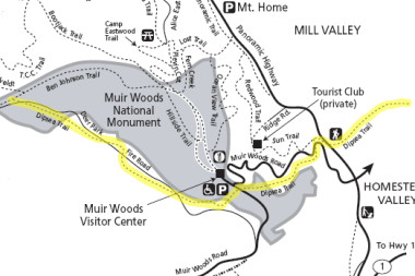
This afternoon I hiked up the famous Dipsea trail, which starts in Mill Valley and ends 7 miles later at Stinson Beach. I would have liked to make it all the way to Stinson, but of course then I’d be 7 miles from my scooter, so I hiked in for about two hours, then I turned around at the Ben Johnson trail and hiked all the way back.
The Dipsea had been through a rough winter: a pretty significant landslide wiped out one section (and the road above it), and a foot bridge over Canyon Creek got washed out. Luckily it wasn’t enough to stop me, I managed to scramble around the various hazards, and continue on my way.
I took a bunch of photos, but by and large I ended up focusing on the recently blooming spring flowers. I can identify the poppies, but if anyone knows the names of the others, please leave a comment.
After bidding our heated tent-cabin adieu, we had breakfast, and then drove up to Badger Pass, a small ski area in the park where they also rent snowshoes.
We all got suited up, and started towards Dewey Point on the recommendation of a park ranger. There are two ways to get to the point, one harder one easier, but the harder route forked off first, and everyone seemed cool with that. What did we know? So off we trudged into the forest.
As promised, it was a beautiful, diverse hike, with lots to see and photograph along the way. The snow was at least two feet deep. Aside from the well-trodden trail, it felt like we were very much in the wilderness, very much on our own. But it was also pretty hard going, with lots of ups and downs and twists and turns.
Given that we had to get the snowshoes back by 4, we were all well aware of our turnaround time—but it created a dilemma: how hard do we push ourselves, how far do we go, would we make it to Dewey Point? I did my fair share of cajoling, but once we reached that turnaround window, and with a reasonably expansive view in front of us, we all stopped to prepare the dinner we had conveniently been unable to enjoy the night before. Hot dogs never tasted so good!
Turns out Dewey Point was just a few hundred feet ahead (we learned from some cross country skiers), so we headed down for a quick look-see before beginning the trek back. The hot dogs were a great reward, but actually reaching our goal and standing on the edge of the world made all the difficulty getting there seem worth it.
By then we really had to get moving back. I was a little worried about the rental office closing on us, but we managed to reduce our return time by taking the less-strenuous meadow trail back (yay, a loop!), which we were all very glad for. It was still really freaking hard, and harder still knowing we had to get back at a specific time. But we all made it—and just in time.
Group shot at the beginning of the hike (Marcia, Joy, Kyle, Stephanie, and Justin)Shadows fall across the trailEveryone taking a breatherStephanie leads the way!Justin cooking hot dogs in the snow (thanks to Joy for the photo!)Dewey Point is just aheadCrazy view with a crazy dropKyle, Joy, and Marcia standing at that crazy dropJustin and Stephanie at Dewey Point (thanks to Joy for the photo!)Snowshoe prints in the meadowIt was kind of a death march towards the end