From Lava Beds to Crater Lake
Over the 4th of July weekend, Stephanie and I traveled to Reno, Lava Beds National Monument, Crater Lake National Park, and Ashland, Oregon. Our route made a nice loop around the less-traveled northeastern corner of California and southern Oregon.

Considering that this was partly going to be a camping trip, it’s kind of funny to admit that we forgot our tent. Luckily we discovered this in Reno, which had an REI, enabling us to upgrade to a spacious new 3-person tent (the Quarter Dome T3 Plus). Next time, we’ll double-check the car camping list!

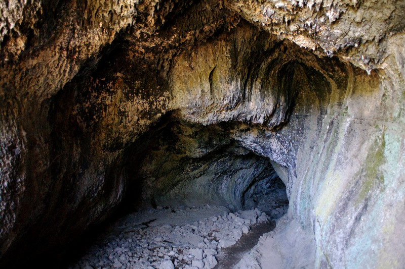
Lava Beds is known primarily for its caves, which were formed over thousands of years by giant lava tubes—a formation where the outer shell of lava cools faster than the lava inside the flow, which eventually drains out, leaving behind a hollow tube. All the caves but one were essentially undeveloped, except for the staircases that protruded incongruously (and yet invitingly) from the ground.

Stephanie is not a big fan of caves (and other tight, dark spaces), but she said she’d at least try one. We both were a little unnerved about being underground, but eventually grew accustomed to them, and explored half a dozen, including one that was a kilometer long. It didn’t hurt that it was over 90°F outside while the temperature underground averaged 55°F, and got down to 30°F (below freezing) in a few caves.

It’s kind of hard to photograph caves, because for the most part they’re pitch black, save for the daylight at the very entrance. But this should give you the sense of the tunnel-like nature of these caves.
After two nights at Lava Beds, we packed up our campsite and left early for Crater Lake. We were going to be spending that night with my cousin in Ashland, so we didn’t have any time to lose. Crater Lake is a very accessible, car-friendly National Park. In essence it’s a lake with a road around it—a lake that just happens to be the deepest in the US (Tahoe is #2), formed out of a collapsed volcanic caldera, and fed only by the purest rain and snow.
I hadn’t looked at any photos of Crater Lake before we left, so we didn’t know what to expect. Arriving from the south in the late morning, we decided to take the road around the lake counter-clockwise, so the sun would always be at our backs (for better photos). Our first stop was the Sun Notch Overlook, a small hike up to the edge of the steep cliffs that encircle the lake. Keep in mind that we hadn’t actually seen it yet. As we were approaching the overlook, we could see the barriers ahead, so we decided to close our eyes as we stumbled up to it. We put our hands on the railing, counted to three, and opened our eyes. WOW. BLUE. It was so blue! Blue like you have never seen blue before.


Yellow swirls of pine pollen on the surface of the lake

We continued along the rim drive, stopping here and there, taking essentially the same photo over and over again (just like everyone else), each time from a slightly rotated vantage point, all-the-while agog at the lake’s incredible beauty and blueness. The boat tours to Wizard Island (the volcanic cone in the lake) had already booked up when we arrived, so the only thing to do besides driving and ogling was to hike the Cleetwood Cove Trail down to the edge of the lake, a distance of only a mile, but an elevation drop of 700 feet. So we did that. Going down was remarkably easy. Pulling ourselves back out was a little more challenging.


And that was it. We stopped a few more times, we snapped a few more photos, and then we hit the road for Ashland in order to make it there in time for dinner.

One last panorama of Crater Lake, for good measure
Wow- Crater Lake is indeed gorgeous! Would the water have been too cold to try out?
Crater Lake is one of my favorite stops in Oregon. Thanks for sharing your trip! I will be camping soon in Oregon myself.
I was at Crater Lake the very next day!
Jonathan, if our paths had crossed, I wonder if I would have recognized you? I hope you’re doing well.
Craig, have a great trip, pack lots of bug spray! I’ve barely spent any time at all in Oregon, California’s just so big and has so many places to explore. I’d like to do a more westerly route going up the coast next.
Claudine, most people hiking down to the lake were more prepared that us, wearing bathing suits in preparation for a cold plunge. We dipped out fingers in, but that’s all.