220 Miles in 11 Days
While hiking with my Dad on the Pacific Crest Trail two years ago, we averaged 18.75 miles-per-day over 8 days. It was difficult terrain, and we encountered snow daily, so it took several days before we reached our target pace. But as I got stronger and the terrain got somewhat flatter, we eventually made it over 20 miles-per-day, several days in a row. My brother Matthew hiked a section through Oregon with Dad, encountered altogether different obstacles, but he similarly managed to cover 160 miles over 8 and a half days.
It was our respective PCT experiences that led us to believe we could complete the 220-mile long John Muir Trail in 11 days. So we took a rough elevation profile of the trail, divided it into 20-mile segments, and discovered that if we followed it blindly, we’d be sleeping at the top of several high passes. A slight re-jiggering was in order, one that would also account for the fact that no matter how much we trained in advance, nothing quite prepared you for the real thing—besides the real thing. Thus we landed at what became our rough 11-day schedule: warming up with two “easy” 17-mile days, before ratcheting it up to 22, 21, 20, 16 (resupply), 24, 22, 22, 22, and 18 miles.
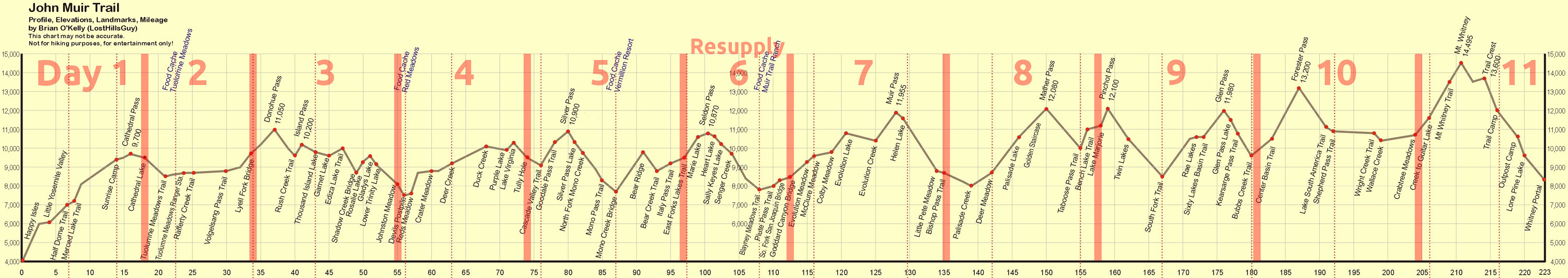
JMT Elevation Profile with our 11-day schedule
Which begs the question, how long is the JMT, really? As it happens, 220 miles is a convenient round number that 11 divides into evenly. According to the Wenk book, the trail is actually 220.8 miles long, though she also rounds down in prose:
This book describes the JMT from its northern terminus at Happy Isles to its southern terminus atop Mt. Whitney, and then to Whitney Portal, the nearest trailhead, for a total of 220 miles of magnificent Sierra scenery.
This explains why our planned daily miles add up to 221, instead of 220. As she mentions, the trail officially ends at the top of Mt. Whitney after 210.4 miles, but of course you have to get off the mountain, which adds another 10.4 miles to the hike. While on the trail, Matthew and I relied heavily on the Tom Harrison Maps John Muir Trail Map-Pack. If you add up all the various trail segments from the maps, filling in a few gaps, and adjusting for minor discrepancies between pages, the total comes out to about 222.9 miles—which might explain the 223-mile length of the elevation profile above. But what’s another mile… mile and a half?
That’s enough JMT administrivia. Lets get on with the hike! Without further ado…
Day 0
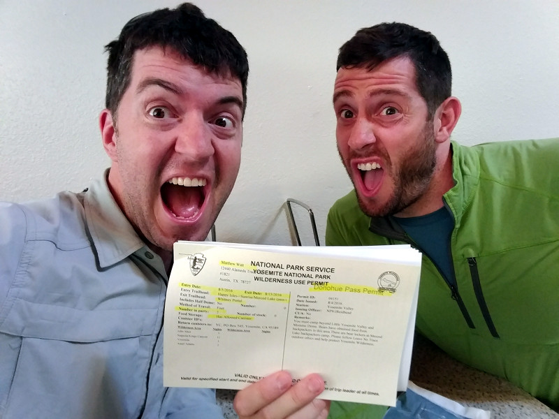
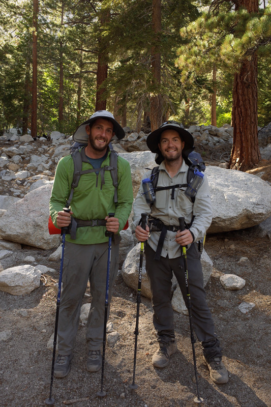
Matthew and I took public transit from San Francisco to Yosemite because Stephanie was busy hosting a family of French friends who were staying with us at the time. Our trip entailed a walk to the 16th Mission BART Station at 6am in full backpacking regalia, a BART ride to Embarcadero, a walk to the Temporary Transbay Terminal, a bus to the Amtrak station in Emeryville, a train to Merced, and a YARTS bus to Yosemite Valley. We got our prized wilderness permit (Happy Isles Pass-Through w/ Donahue Pass Exit) at the Wilderness Center, before grabbing a pizza for lunch—which we ended up sharing with some of our fellow backpacking bus-mates. Matthew left his hat at home, so we went out in search of a replacement, as well as a few other odds and ends. Our late lunch left us with little appetite that evening, so dinner was hot Cheetos with a bunch of these little margarita bottles.
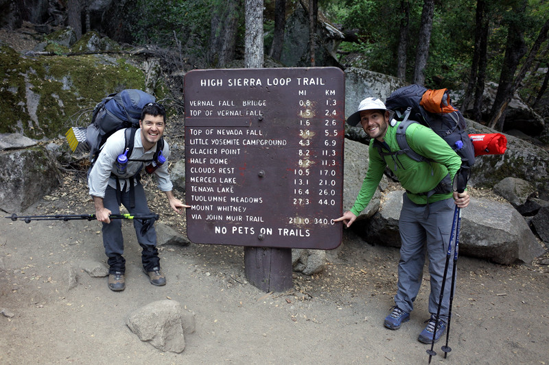
Day 1
We came to hike the JMT, so we skipped the Mist Trail shortcut (which we’d hiked together 3 years ago) and opted for the longer and more gradual switchbacks of the Muir Trail proper to start things off. Matthew’s recently resewn pants split at the crotch and started to rub his inner thighs, necessitating an on-trail repair which met with little success. What were the chances of finding a replacement in Tuolumne Meadows the next morning? The ~1000-foot ascent just before Sunrise High Sierra Camp really crushed us. Stopped there for water. We were bushed, it was 4pm, and we still had 5 miles to go. Not a good feeling. After yet another climb over Cathedral Pass we made it to the Upper Cathedral Lake turn-off, where we’d planned to camp for the night. It was after 7 when we finally got to the lake.
Day 2
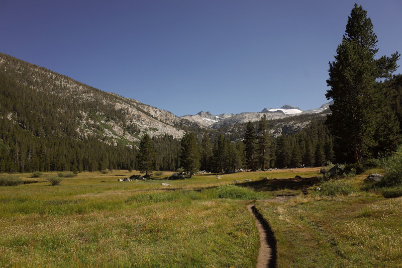
Woke to a heavy layer of frost on our tent-fly and backpacks. It got much colder at night than we expected. We bumped into Kim on the way to Tuolumne Meadows and ended up hiking with her all day and half of the next. While she resupplied at the Store/Grill, Matthew used her mattress patch kit with superglue to repair and reinforce the crotch of his pants. The patch held, but the rough edges of the repair continued to rub his legs raw. While there we treated ourselves to breakfast sandwiches and coffee! Dipped in Lyle Fork during a late lunch break and washed shirts and socks. We found a great campsite at 4:30pm, but realized we were 2-3 miles short of our 17-mile goal for the day. Of course the last bit was all switchbacks—all up. We ended the day just after the bridge over Lyle Fork.
Day 3
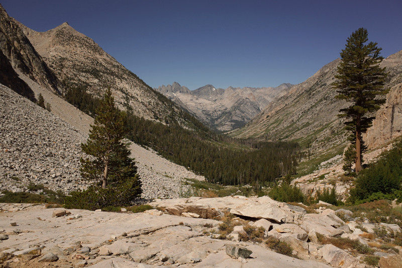
Climbed up and over Donahue pass to start the day. Matthew discovered he had cell service just after the pass so we sent updates/selfies back home. Soaked our sore feet in the incomparably beautiful Thousand Island Lake. We separated from the PCT, taking the JMT’s low route, which involved a lot of ups and downs as we hiked from lake to lake. We didn’t have a well-defined stopping place for the night, but needed water, so continued all the way to the boggy, buggy Johnston Meadow. We were eating dinner in our tents (to avoid the mosquitoes) when several [escaped?] horses came galloping through our campsite, some within a few feet of our tents. Scary.
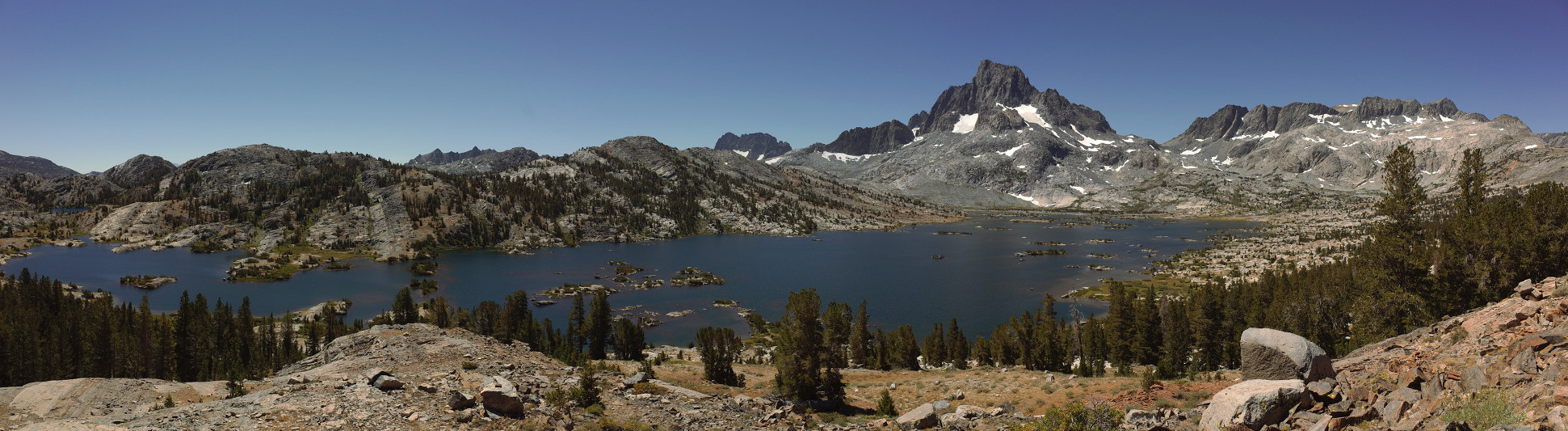
Thousand Island Lake Panorama
Day 4
Passed through Devils Postpile National Monument and decided to stop at Red’s Meadow Resort. We treated ourselves to a surprise sit-down breakfast, dumped food we weren’t eating, and found some Ace bandages to protect Matthew’s legs from his pants-crotch repair job. We felt stronger that afternoon, but still found ourselves at 5pm with 4 miles to go—confronting a tough climb up to Lake Virginia followed by a steep descent down to Tully Hole, where we planned to spend the night. It was buggy again, so Matthew cooked inside his tent—I’d cook outside but eat inside—and he accidentally melted a fist-sized hole in his tent’s mesh wall! Oops.
Day 5
Spent the morning hiking up and over Silver Pass and then all the way down to the Vermilion Valley Resort turn-off (where we were not planning to stop). After lunch we began the infamous switchbacks up to Bear Ridge, which northbound hikers had been warning us about for days. They were endless, but we crushed them. By the end of the day, though, our feet were crushed, so we sat on a rock together and soaked them in icy Bear Creek while filtering water for the night and the next morning. It was a total bro-JMT-foot-spa-bonding moment.
Day 6
We hiked by Marie Lakes in the morning on our way to Seldon Pass. Danny had suggested camping there, but we just couldn’t push ourselves to hike beyond 7pm the night before. We joked to ourselves that “we were here to hike not to camp”. Day 6 was our sole resupply day, and thankfully it was downhill all the way from the pass. We got to Muir Trail Ranch just after noon, and set to unpacking the bucket I’d packed for us 3 weeks before, leaving behind a bunch of stuff that we just didn’t have appetites for, and then repacking our bear cans. I was also able to email Stephanie and our parents to let them know we were alive—this would be the last communication we’d have with the outside world until the very end. We stopped at Piute Creek to filter water and soak our feet. A whole “beach” of people formed around us, sunbathing, swimming. We continued on, entering Kings Canyon and hiking until just before the switchbacks up to Evolution Valley. Miraculously we finished the day before 6pm! It was warm! And no mosquitoes!

Day 7
Up to that point we’d been setting our alarms for 5:45am, and usually getting on the trail around 6:45am. But with the big passes ahead, we decided to start waking at 5:30am. The hike through Evolution Valley was gorgeous. The climb to Muir Pass was endless. The last push was brutal. We rested for a while at the top to hang out with some of the other hikers passing through. At all points along the trail it was interesting to hear where people were coming from (that morning and originally) where they were going to (that evening and eventually), and how many days they were planning to be out. Within that basic framework we learned all sorts of things about the people, the trail, and the collective JMT experience.
Day 8
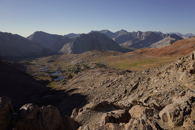
Saw a bear! My first bear sighting in the Sierras. We must have startled it, just across Palisade Creek, not more than 30-50 feet away. It immediately bounded off—then stopped. It turned its head to stare directly at us for a second or two, and then continued into the woods and out of sight. It was a nice reward just before the Golden Staircase. We stopped at Lower Palisade Lake for much needed laundry and bathing before continuing the climb up and over Mather Pass. After a long downhill stretch, the day ended with a killer ascent up to the Bench Lake trail junction. We planned to camp at Lake Marjorie, but ended up landing at the small lake just before it.
Day 9
Pass doubleheader! We went over Pinchot Pass just as the sun was coming over the mountains. Of course we had to drop downhill only to reclaim the same elevation and then some. We reconnected with a section of the trail that forms part of the Rae Lakes Loop, which I hiked with Stephanie 2 years ago. By the time we got to the lakes, Matthew started peeing blood. His pee was red and frequent for the rest of the day, before dissipating the next morning. Apparently we were working him too hard. Nothing else seemed to be bothering him so we muscled up and over Glen Pass. We held it together until the very end. The last set of switchbacks just before Vidette Meadow, where we planned to camp, were comically endless.
Day 10
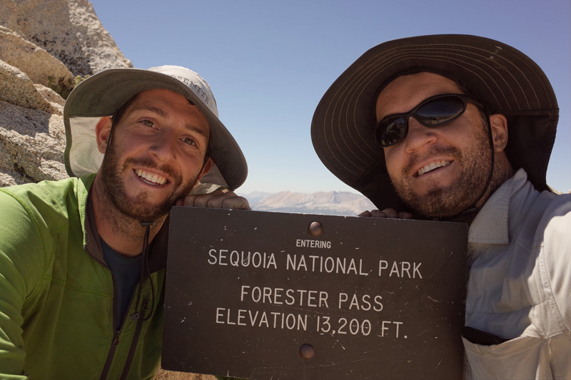
My camera, which I had dropped into Woods Creek under the suspension bridge after lunch the day before, miraculously powered up and seemed unaffected. We spent the whole morning climbing up to Forester Pass, the highest, the scariest (depending on the snow—there was none) and the final pass on our way to Mt. Whitney. Getting to this point was a triumph, once almost unimaginable, and I think afterwards, we both started feeling ready to be done (read: cranky). A rare hot lunch of Lipton’s chicken noodle soup procured from the hiker box at MTR and inspired by a similar hot lunch I shared with Dad on the PCT helped to fortify us. We felt like hiking machines during the last set of ups and downs between Wallace Creek and the turn-off for Crabtree Meadows. Our last night on the JMT. We were beat.
Day 11
If there was one unassailable truth I could depend on every day during the hike, it was that no matter how destroyed and abused our feet felt by the end of the day, they always felt pain-free and ready-to-go in the morning. We made good time to the turn-off for Mt. Whitney, already higher than Forester Pass. Then it was 1.9 miles and another 1100 feet to the summit—the highest peak in the contiguous 48 states. Before the top, with the hut out of sight but just within reach, the enormity of what we’d accomplished flooded my system: months of planning and anticipation, 11 days, 210.4 miles, innumerable passes, ascents, and switchbacks, and here we were. I got emotional. Tears, more like sobs, were shed. And then we were “done”. Done with the official JMT, but still 10.4 miles and 6000 feet of elevation to descend before reaching Whitney Portal, where Stephanie was due to pick us up. Matthew had cell phone service at the tippy top, so we were able to contact the world for the first time since day 6 to let people know we were alive, well, and incredibly, still on the schedule we’d set for ourselves. It was a LONG way down, but it was down, and the last down, complete with interminable switchbacks to send us off. Stephanie surprised us 45 minutes up the trail and hiked the last bit with us. And then we were really done, with so much to catch each other up on—but first a burger with a side of hot dog at the Whitney Portal Store.
Love your hiking posts. Thanks for sharing your JMT adventure!
Great trip report – loved reading it and reliving the bits we heard about! I don’t think you guys camped anywhere where we camped! Gives me inspiration to work on my own recap… and yes, no matter how you well you think you prepare, nothing indeed does prepare you like the actual thing itself! <3!
Nice write-up – good to get it down while memory is fresh! Such massive miles, no wonder baby bro peed blood. :) And I am still jealous of your bear :)
an Incredible feat Justin. I love the trail report, and congrats to you and Matthew!
well done guys!