tata grand canyon is bangala
as i drove back to the grand canyon from williams, i flipped on the radio for the first time this trip and eventually stumbled upon npr doing a piece about blind tibetan teenagers attempting to climb a himalayan peak. how humbling i thought later. and how appropriate. i got to the grand canyon, paid for a year long national park pass. got a map and a newspaper guide. knew i wanted to hike, but didn’t know where.
there’s a rim trail, which wanders around the rim, but i didn’t want to stay at the top of the canyon, i wanted to go down in. however in my meager research the night before, i discovered that it takes two days to go from the rim to the colorado river and back again. they seemed pretty serious. i certainly didn’t want this happening to me. since i thought hiking down to the colorado river was the whole point, and since i wasn’t prepared for any kind of camping, i was unsure of what to do.
eventually i realized there were trails that went into the canyon but not all the way to the river, so i settled on the bright angel trail, mostly because i could identify it clearly on a number of maps. it started nearby, and was composed of several segments, the longest of which was estimated to take 8-12 hours round trip (12.2 mi!). well, i had the whole day, so i figured i’d see how i felt at each checkpoint and determine whether to turn around or keep going.
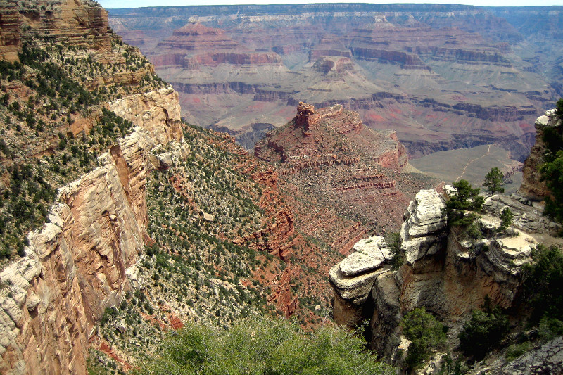
this is what the grand canyon looks like from the bright angel trailhead. the day started out overcast, which made everything look kind of gray. also worth noting is the vegetation in and on the canyon. i was told that the southwest has seen record levels of rainfall this spring, so apparently everything is denser and greener than it has been in 10 years.
i hiked down and down and down. in the beginning i “ran” it, until my feet felt like they were on fire. since i had been thinking “trail running,” i wore running socks, which are quite thin, even though i had thick, synthetic wool hiking socks in my suitcase. oops. slight miscalculation.
i kept going down and down, eventually covering 4.6 miles, descending 3060 feet into the grand canyon when i made it to the last checkpoint before the end of the trail, called indian garden. here i refilled my water and decided whether to take the last leg, a 1.5 mile hike along a relatively flat plateau, presumably with stellar views of the “inner canyon.” are you kidding me? hell yeah!
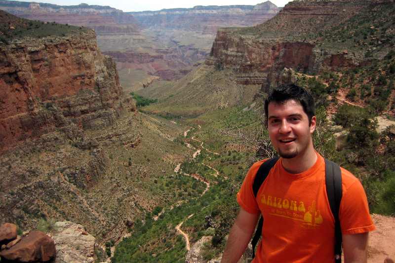
to my bemusement, the clouds began to break, promising better pictures, but a hotter justin. it’s also quite a bit warmer in the canyon. at some point in the middle of the plateau, i turned around and snapped this shot looking back from whence i came. at no point in the course of this hike had i thought one iota about hiking back up out of the canyon.

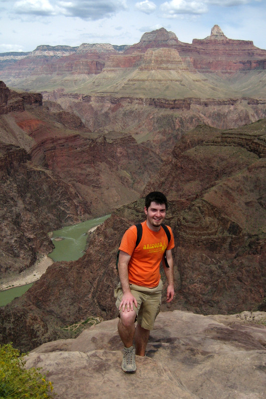
finally success is mine! the colorado river in sight!
suffice it to say, it took a lot longer getting out of the canyon than it took getting in. i think i started a little before 11am and estimate that i got to the plateau point around 2. i emerged from the grand canyon 5 hours after that. a good bit of the last part i was walking like an old man, a few inches at a time.
my legs and shoes were caked with red dust and sand. my feet were blistered. my back ached and my quadriceps screamed. i was limping. i could barely take a full breath without triggering a cough reflex. it was SO awesome.

next leg: grand canyon to st. george
Mmmm, I have such fond memories from that part of the world from outward bound. Trench foot, watery chili and stale bagels, pooing into a paper bag, the bear attack, the 12 hour-days of paddling. I loved it.
geez, how are you feeling today? methinks you made up for all that time sitting in the car.
Ah yes, the red dust :) I have an old pair of hiking boots that still look red 10 years after hiking the canyon.
Did you go to the Desert View and check out the black glass?
Ever since I saw the movie “Grand Canyon” on a date with Erin in college, I’ve wanted to get there and hike into the canyon. Thanks for giving me another reminder of that goal. Glad to hear you made it down and back in one piece.
i thought the grand canyon would be kind of orange, but it turns out it’s not nearly as orange as you.
jackie, today (meaning sunday) i went to zion national park and hiked for another full day! post forthcoming.
kansas, nope, saw the desert view signs, but didn’t know what it was and had to make tracks to my next destination: zion.
i highly highly recommend the grand canyon to anyone fit or foolhardy enough to hike down into the canyon. i loved it. it was one of those singular experiences that expanded my perspective three dimensional space. the scale and depth and breadth of the canyon was just unfathomable.
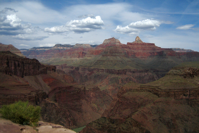
and it kept changing. as i descended into it, my perspective changed, as i moved toward the colorado river on that plateau, the canyon enveloped me, and i was actually looking up at it rather than down. and of course as the day progressed and the weather changed, shadows cast different shapes against the canyon walls than they had hours earlier.
in other words i’m saying i took 243 pictures and 3 movies. but i’m also saying, go see the grand canyon. especially in the early/mid spring. it rocks!
I remember hiking the Bright Angel trail, but I think I went down only 2 miles. Congratulations! You’ll have to stop by the frozen custard place in St. George … I think they call it “concrete”???
I can relate to that so well. We were so stupid and did not bring any water :-) I know I know, but to make matters worse we had a litre of pepsi :-) We would walk for a few minutes and then have to rest for a while longer
yea this really helped me out for a report i had to do for school.
its kinda krazy i’ve lived in arizona almost all my life and never been to the grand canyon.=(
Ahh, good memories! If anyone wanted to hike Grand Canyon, it is best to go between December to March. It is very warm at the river in the bottom of the canyon. When I went, there were snow on both rims. But when I got to the bottom, it was about 95° F! It took me about 7 hours or less to get to the bottom of the canyon, but it took less than 2 days to get back up the rim.
That’s right when you said there was a record rainfall, I remember 2005 was a very green year in Arizona! I was at Lake Pleasant that summer.
Zion National Park is also a beautiful place, too! Did you drive through the tunnels? My sister was so insane! It was night time when we were driving through the tunnels, she turned off the headlights for a few seconds! That evil bitch.
Since you’ve been to the Grand Canyon and Zion National Park, did you go to Lake Powell?
We Hiked the GC, rim to rim in July of 2003 in record heat no less! We started @5:30am on the north rim (14 mi) and it was 65 degrees and hiked 12 hrs down and it was 116 degrees when we reached Phantom ranch @5:30pm that evening. Whew glad we made it! I threw water on me the whole way down, I never thought that I would hike wet, but it was sure helped in the heat. We hiked out 2 days later up the South rim (10.3 mi). Glad I did it but I want to go again in the fall or spring when it is not so hot!! It was hard to concentrate on all the beauty around you when it is 110+. =)
Bring water, good shoes & socks and mole skin.
My dad and I hiked to Indian Gardens in mid August and it was hot outside, at the rim it was 75 degrees and at the Indian Gardens it was 105 degrees. Before we left my dad told my mom what time to pick us up so we were limited to how far we could go, plus our cellphones had no reception down there to call and tell her if we were going to arrive late. It took about 7 hours for the round trip.
i am hiking the same trail. in a month, any pointers?
oregon: 2-3 pairs of thick socks (1 for going down, 1-2 for coming back up), lots of water, lots of salty snacks (nuts, trail mix, chocolate, granola), a camera
The Grand Canyon is very very cool.
fantastic pics. thanks for sharing. i’m going in august and this gave me an idea of what to expect.
My buddy and I are going to Utah from 8/30 – 9/10. We intend to include the GC in our trip. Your pics are amazing. What type of camera did you use? I hope to have my hydration pack in the next month or so too.
I can’t decide how much time to spend in each of the National Parks at this point. We’ll be flying into SLC. The heat shouldn’t be a problem b/c we live in South Carolina. However, the elevation will be another story.
Brian, it was a Canon Digital Elph/Powershot. Highly recommend any of their SD models. Very small and easy to keep in a pocket while hiking with lots of other gear.
You started in Williams? Where did you stay there? I really like a bed and breakfast in Williams called “Grand Canyon Bed and Breakfast” http://www.grandcanyonbandb.com
cool place and a great launch for a day by the big hole in the ground!